
Missouri's Sloping Forehead
May 2026
That question is a reliable stumper in a trivia battle about Missouri. Sure, most folks can name the Mississippi and the Missouri. But identifying the other two river borders nearly always requires a lunge for the atlas.
One of those rivers is the St. Francis. On a map, it helps outline Missouri’s most distinguishable characteristic, the instep of Missouri’s fashionable Bootheel.
The fourth river? It flows across Missouri’s sloping forehead, along a county named for the commander of the Corps of Discovery. For about 25 miles, the Des Moines River borders the very northeast part of Clark County in the very northeast part of the state. Most folks just assume that when our ancestors carved out Missouri, they drew the state with a flat top, a straight line from the Mississippi across the Show-Me State’s noggin. Look closer. A chunk of Iowa extends 16 miles south of Missouri’s northern border. That southernmost Iowa appendage looks nothing like a fashionable “bootheel” so the corresponding dent in Missouri’s northeast corner goes mostly unnoticed.
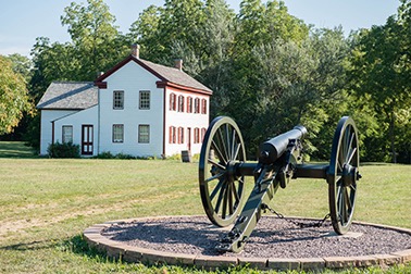
By the time my car delivered me to the Battle of Athens State Historic Site, I felt as tired as Mark Twain retreating (look it up). Indeed, in this northeasternmost part of Missouri, we’re closer to the state capitals of Iowa and Illinois than Missouri.
I can understand why people would want to settle here, and I promptly nestled into a secluded campsite myself and explored the Des Moines River Ravines Natural Area. The park enjoys a mile and a half of river frontage and enough hills and woods to get lost. The rolling hills and beautiful scenery stand as irrefutable proof that north Missouri is much more than flat farmland. Clark county boasts five separate conservation areas for hunting and fishing, plus the Great River National Wildlife Refuge along the Mississippi.
Driving south from Athens along the Des Moines River, I came upon the Illiniwek Village State Historic Site, the only known summer village once inhabited by the Indians of the Illiniwek Confederacy. The Illiniwek, or Illinois Indians, were prevalent when Europeans first came to Missouri. The village looks different today than it did back in 1673 when Marquette and Joliet visited the 8,000 villagers. The 300 lodges along a network of streets are reduced to an archaeological dig. Still, this village is the biggest and best-preserved of the Illiniwek culture.
My car doesn’t care that I’m the great-grandson of an Irish Catholic priest. Yet she obliged as I took a circuitous route from Illiniwek to the village of St. Patrick, not far from the Wyaconda River. I got a kick out of hanging out in the only place in the world where you can send a letter postmarked with the name of this legendary evangelist.
There’s a lot to discover, all tucked under this border river along Missouri’s sloping forehead.